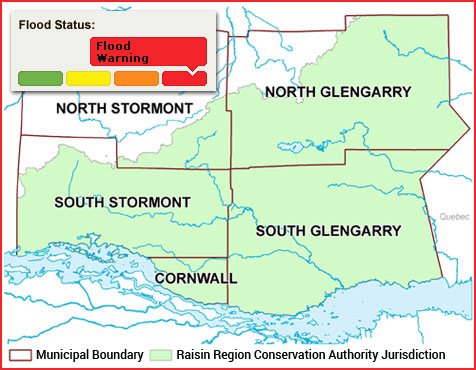
Yesterday’s heavy rains have caused the water level of streams and rivers to rise to their highest levels since spring 2017. However, damage from freezing rain has disrupted communication with several of the region’s stream gauges, leading to uncertainty regarding the current extent of flooding in the RRCA jurisdiction.
Rivers have risen and spilled their banks in many locations across the region. Some low-lying roads alongside rivers and creeks are flooded. These include:
- Sections of McGillivray’s Road between Martintown and County Road 27.
- Chapel Road, between the Beaudette River and Caber Road.
Overland flooding is also affecting many roads in the region.
Do not drive through floodwaters: Water can hide flood damage to the road, which could include washed-out sections of road. Strong currents can sweep vehicles off roadways.
No further rain is forecast for the next week. The rate of flow increase in waterways across the region is slowing, and it is expected that water levels will reach their peak today or tomorrow.
This statement is in effect until Saturday, April 8, 2023, at 4:00 PM. This statement replaces the Flood Outlook Statement issued on April 4. The RRCA will continue monitoring water levels and weather forecasts as part of the Flood Forecasting and Warning program. Updates will be provided as information becomes available.
For more information: Halya Petzold, Resource Specialist, 613-938-3611 ext. 244, floodforecasting@rrca.on.ca